
 Yahoo Sport


Thunderstorms cause floods across Ireland
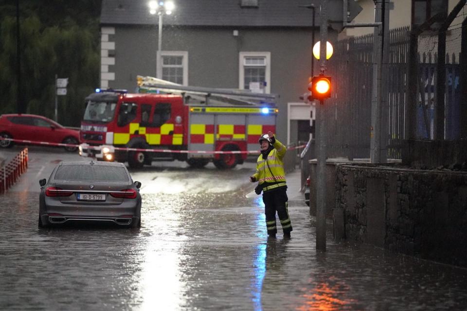
Heavy downpours and flooding have hit parts of the island of Ireland as thunderstorms marked the end of the heatwave.
Met Eireann extended a status orange thunderstorm weather warning to 10pm on Monday night for Munster as well as counties Wexford, Carlow, Kilkenny, Laois, Offaly, Kildare, Wicklow and Dublin.
Orange Thunderstorm Warning updated.
Valid 09:00 to 22:00 Monday 15th.
Heavy downpours of rain and hail.
Flooding where heavy downpours occur.⛈️
➡️https://t.co/Xg3aMJlyuS pic.twitter.com/gOCAAIJw8F— Met Éireann (@MetEireann) August 15, 2022
“Heavy downpours of rain and hail will occur in places,” the meteorological service said.
“Flooding where heavy downpours occur.”
⚠️ROAD CLOSED⚠️
R725 closed in Tullow town between Applegreen and Tullow bridge due to flooding.
Please avoid Tullow town until further notice @kclr96fm @Carlowlive1 @CWnationalist @allaboutcarlow @CarlowPPN pic.twitter.com/o1kuYqMjaE— CarlowCountyCouncil (@Carlow_Co_Co) August 15, 2022
In Carlow there were flash floods in Tullow town on Monday night.
Motorists were asked to avoid the town after a number of roads were closed, including Castledermot Road and the R725 between Applegreen and the Tullow Bridge.
In Wexford, there was severe flooding in New Ross town on Monday afternoon and evening following heavy rainfall. People were urged to avoid the quays and drive in other areas with extreme care.
⚠️ Heavy flooding in the New Ross area this evening. Quays in particular. Please avoid the area if you can, use alternative routes and drive with extreme care⚠️ @beat102103 @SouthEastRadio @GardaTraffic
— Wexford County Council (@wexfordcoco) August 15, 2022
Wexford County Council said there would be interruption to water supplies until at least 10am on Tuesday in the areas of Kilmore, Duncormick, Rathangan, Killag, Wellington Bridge and Bannow.
The forecaster added not all areas would be affected due to the “sporadic nature” of thunderstorm activity.
Showers continuing this evening, heavy in places with thunderstorms in parts of Munster and south Leinster, bringing a continued risk of flooding.⛈️🌧️
Crosses indicating intense thunderstorm activity pic.twitter.com/jK0cAnRh8h— Met Éireann (@MetEireann) August 15, 2022
A small craft warning from Roches Point to Slyne Head to Malin Head was also in place on Monday with northerly winds expected to reach force 6 or higher. It was due to end at just after midnight.
The downpours came after the heatwave ended on Sunday night with thunder, lightning and flash flooding in many places.
Weather for week ahead
Temperatures will generally be in the mid to high teens this week
Tuesday & Wednesday will be fresh days with plenty of dry weather & a few light showers
Becoming milder again on Thursday with some rain at times
A mix of showers & sunny spells on Friday pic.twitter.com/01R1FGkoxk— Met Éireann (@MetEireann) August 15, 2022
Met Eireann said temperatures for the rest of the week will be generally in the mid to high teens. Tuesday and Wednesday are expected to be “fresh days with plenty of dry weather and a few light showers”, the forecaster added.
It is set to become milder on Thursday with some rain at times, while Friday is expected to bring a mix of shower and sunny spells.
In Northern Ireland, thunderstorms on Sunday that caused the Met Office to issue an amber weather alert warning of hail, lightning and potential flooding came to an end on Sunday night.
On Monday evening it forecast some heavy showers at first across Antrim and Down. Otherwise the Met Office said it would be a “cloudy evening and night with some patchy mainly light rain”.
Tuesday was expected to be “rather cloudy with some patchy light rain” that would gradually clear. The forecast for Wednesday was due to be mainly dry with prolonged bright and sunny period.
